South Park Chamber of Commerce


FAIRPLAY | ELEVATION 9,957'
 Fairplay is the seat of Park County and the largest town in the South Park area. It is located at the crossroads of Highway 285 and Highway 9. Anyone driving through this historic mining town should make time to visit the South Park City Museum. It explains the history of the area from the Native American tribes that called this area home; to the early miners who founded the town; to the more recent history of sheep and cattle ranching. Make to visit historic Front St, full of local artisans, restaurants, and gift stores.
ALMA | ELEVATION 10,578'
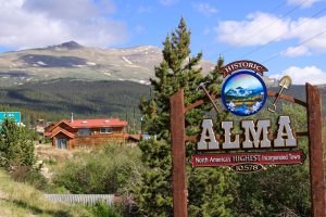 Alma is the highest incorporated town in North America. It is located on Highway 9 between Fairplay the Hoosier Pass, just 15 minutes from Breckenridge. Alma also a rich mining history and mines are still operating in the surrounding area. One of the best events is hosted by the Alma Foundation, Festival in the Cloud. It is held the third weekend (check event calendar for exact dates). Festival is a mini Woodstock, that is family and dog-friendly, something for everyone.
COMO | ELEVATION 9,800'
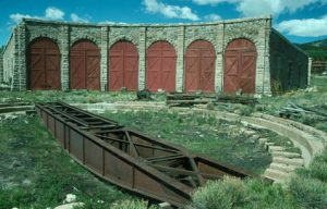 Como is located east of Fairplay off Highway 285 and County Road 33. It was the historic station of the Denver, South Park and Pacific Railroad. The beautiful roundhouse is being restored, and several events center around it every summer. The roundhouse is on the National Register of Historic Places. Spending time in Como is like stepping directly into the past.
JEFFERSON | ELEVATION 9,499'
 Como is located east of Fairplay off Highway 285 and County Road 33. It was the historic station of the Denver, South Park and Pacific Railroad. The beautiful roundhouse is being restored, and several events center around it every summer. The roundhouse is on the National Register of Historic Places. Spending time in Como is like stepping directly into the past.
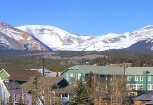
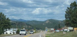
HARTSEL | ELEVATION 8,860'
![]() Hartsel is a town that embraces its ranching heritage. It is located on Highway 24 and Highway 9, between Fairplay and Canon City. Hartsel is the closest town to the Gold Medal trout fishing of Spinney Mountain Reservoir and 11 Mile Reservoir, which is connected by the Dream Stream trout spawning stream. Antero Reservoir is a short distance driving west on Highway 24. The Colorado-Midland Railroad went through Hartsel, and the depot is still there, and the train bed is visible most of the way to Buena Vista.
Hartsel is a town that embraces its ranching heritage. It is located on Highway 24 and Highway 9, between Fairplay and Canon City. Hartsel is the closest town to the Gold Medal trout fishing of Spinney Mountain Reservoir and 11 Mile Reservoir, which is connected by the Dream Stream trout spawning stream. Antero Reservoir is a short distance driving west on Highway 24. The Colorado-Midland Railroad went through Hartsel, and the depot is still there, and the train bed is visible most of the way to Buena Vista.
GUFFEY | ELEVATION 8,700'
 Guffey is a town clinging to its frontier roots. It has hardly changed in 100 years, except for a few new homes and restaurants that dot the landscape. It is an authentic Colorado experience! It is easy to get to between Hartsel and Canon City, and it is worth the 1-mile side trip. While visiting, enjoy a meal and stroll along the dirt roads.
LAKE GEORGE | ELEVATION 8,000'
 Lake George is located on Highway 24 between Hartsel and Woodland Park. It is named after the man who cut ice from the lake to load onto the Colorado-Midland Railroad, as it was traveling from Buena Vista loaded with fresh lettuce. It is at the turnoff for the beautiful Eleven Mile Canyon. The tracks are gone, but cars now drive on the old train bed and through the hand cut tunnels. Fishing and camping are terrific in the canyon.
TARRYALL | ELEVATION 8,714'
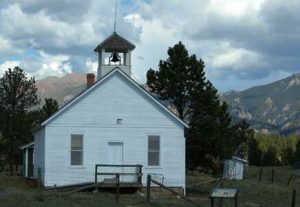 Tarryall was founded in 1859 and was part of the Colorado Gold Rush. It was first called Puma City but was renamed after the Tarryall diggings. Tarryall Creek flows into the reservoir. It is an excellent place to camp and fish, but there aren’t many other amenities there today. The drive from Jefferson to Highway 24 near Lake George is worth exploring.
Dues: $150
Multiple Business Membership – 25% off Annual Dues
2023 ADDED OFFERINGS FROM SOUTH PARK CHAMBER MEMBERS:
50% off from AMP Agency for web design, social media management and graphic design
Free Business Card, Letterhead, and Envelope design from Stratton Design Co.
NEW BUSINESS IN TOWN?
If you’re looking to introduce your business to the county, consider a ribbon cutting ceremony!
The South Park Chamber of Commerce offers ribbon cutting events to new and reopening business members, free of charge.
This is an excellent way to spread the word in the area and meet with your community. Please contact info@southparkchamber.com for details.